







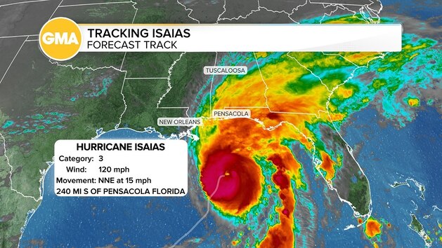
Hurricane Isaias is a Category 3 storm currently headed toward the Gulf Coast, with landfall expected Friday evening along Florida's Panhandle.
The storm strengthened from a high-end Category 2 hurricane into a Category 3 hurricane Friday morning ahead of landfall, which is expected between 8 p.m. and 10 p.m.
Rain reached the Florida Panhandle early Friday and is expected to spread across the central Gulf Coast as tropical-storm-force winds are expected to pick up, followed by hurricane-force winds in the afternoon.
Landfall is expected within 40 miles east or west of Pensacola, possibly between Pensacola and Destin with the most destructive conditions expected near the storm's center and east of where it makes landfall, meaning the area from Pensacola to Panama City could bear the brunt of the hurricane.
The storm was located about 195 miles south of Pensacola Friday morning as maximum sustained winds reached 120 mph.
Destructive conditions are expected and power outages could last for an extended period, particularly in the Florida Panhandle.
The last hurricane to make landfall in the United States was Milton, which came ashore south of Tampa near Siesta Key, Florida, on Oct. 9, 2024 -- exactly two years ago from Friday. In 2025, the U.S. went through its first year in a decade without a hurricane making landfall.
A hurricane warning is currently in effect from just east of Biloxi, Mississippi, through Mobile and Pensacola to Panama City and Mexico Beach, Florida where wind gusts in these areas could reach 75 to 110 mph.
Storm surge of 5 to 7 feet is also possible from Dauphin Island and Gulf Shores, Alabama, to Pensacola, Miramar Beach, Laguna Beach, Panama City, Destin, Mexico Beach and Port St. Joe, Florida.
The storm surge forecast from the Santa Rosa/Okaloosa County Line, Florida, to Grayton Beach, Florida increased to 9 feet Friday morning.
A storm surge of 4 to 6 feet is possible in Biloxi, Gulfport and Bay St. Louis, Mississippi, where the rising water could be accompanied by waves reaching up to 30 feet in some places.
Evacuation orders are in place for many low-lying and coastal areas in Florida.
Evacuations are particularly important in areas at risk of storm surge, Florida Gov. Ron DeSantis said in a press conference Friday morning.
"The surge is really what puts people's lives in jeopardy if they haven't heeded evacuation orders," DeSantis said. "We always say: You hide from the wind, but you run from the water."
A tropical storm warning is also in effect from the eastern coast of Louisiana north to Tallahassee, Florida, and extended further north Friday morning to encompass Birmingham, Alabama.
Hurricane-force winds are expected to occur along Isaias's track up to 100 miles inland from the coast. Wind gusts are possible up to 120 mph.
The storm is expected to fluctuate in strength throughout the afternoon as it approaches the coast, and may weaken after landfall.
Rainfall totals of 4 to 8 inches, with isolated maximum amounts of up to 15 inches, are possible across southern Alabama, the Florida Panhandle and the Big Bend region of Florida.
The coastal Carolinas and southern Appalachians could receive 3 to 5 inches of rain, with isolated amounts reaching 10 inches and the rest of the Southeast is expected to see widespread rainfall of 1 to 3 inches, with some localized areas receiving up to 5 inches.
Flash and urban flooding are likely across the region, with considerable impacts possible across much of southern Alabama, the Florida Panhandle and southwestern Georgia. River flooding is also expected, and some areas could experience significant flooding.
DeSantis said Floridians should assume they will lose power and prepare accordingly, including ensuring adequate food, water, gas and medications for a 72-hour duration.
The Florida National Guard, Florida Department of Health, Florida Department of Transportation and other emergency response teams have mobilized in preparation for power outages, rescues and evacuations.
Copyright © 2026, ABC Audio. All rights reserved.